AWESM-ly Spaced Out
Spatial Technologies Track Pronghorn and Promote Nebraska Precision Conservation

Nebraska is an agricultural hub that utilizes 92% of its land to raise livestock and grow crops, leaving minimal space for native wildlife like pronghorn.
Andrew Little, assistant professor and extension specialist in the School of Natural Resources at the University of Nebraska–Lincoln, utilizes spatial technology, such as global positioning systems (GPS), to learn about wildlife movement patterns.
Little said researchers gather data using spatial technology to inform landowners and different agencies on how to plan and implement conservation practices that benefit the environment while also maximizing agricultural profit.
“Increased agricultural output, larger field sizes and the removal of non-crop native plants has contributed to declines in wildlife populations across Nebraska over the last 50 years,” Little said.
From individual fields to entire landscapes, Little’s lab, known as the Applied Wildlife Ecology & Spatial Movement (AWESM) Lab, is focused on studying wildlife and habitat management in major agricultural areas. The AWESM Lab provides science-based information to help landowners and management agencies balance the needs of agriculturally dominated landscapes and create diverse ecosystems.
Katie Piecora, graduate research assistant working with Little in applied ecology, currently researches the movement of pronghorn which has not been heavily monitored in Nebraska for 20 years.
“The AWESM Lab’s research is critical to help inform management decisions and guide the development of strategies to conserve wildlife while protecting the assets of Nebraska’s ranchers and landowners,” Little said.
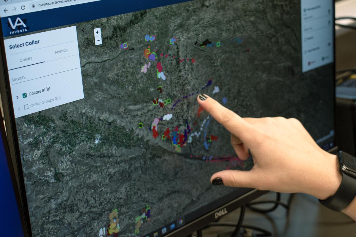
GPS Collars Track Pronghorn
Since February 2021, Piecora has collared 110 individual pronghorn currently living in Nebraska with GPS collars. These collars track the pronghorns’ location like apps on cell phones track peoples’ location.
"Using GPS collars is advantageous when researching roaming animals like the pronghorn because they collect substantial amounts of data over hundreds of miles and over several months,” Piecora said.
Piecora said that GPS collars record pronghorn locations every two and half hours and send these positions through a satellite to a database where researchers can access the data at the University of Nebraska–Lincoln.
“Current data shows that, regardless of season, sex, or area, that pronghorn are strongly selecting to stay in locations with crops which substantiates what we've been hearing from farmers and landowners,” Piecora said.
Piecora’s research aims to answer two key project objectives by identifying the movement and habitat use of adult pronghorn and evaluating their survival.
Data Findings Support Nebraska’s Natural Resources and Farmers
The usage of spatial technologies is essential to Nebraska because the data collected by using them advocates for the protection of native species while also improving the land for crop and livestock producers.
Piecora said that Nebraska’s native grasslands have greatly changed through increased crop production and infrastructure which can negatively impact wildlife.
“Understanding how wildlife like pronghorn respond to agricultural changes is key to effectively managing grasslands to maximize wildlife populations, while also maintaining sufficient agricultural and energy outputs,” Piecora said.
After analyzing their data, researchers communicate their findings into formats that are readily available to the public. This provides landowners with accessible information capable of improving their land and resource yields.
The AWESM Lab research team focuses on identifying new ways to increase farmers’ income by showing how they could benefit from the introduction of native ecosystems and wildlife on their properties. Ecotourism is one example.
“Collaborative research and extension projects benefit both Nebraska’s farmers and wildlife by helping landowners best manage their farm to feed a growing world while ensuring conservation of Nebraska’s important natural resources,” Little said.
Spatial Technology-Driven Conservation: Nebraska’s Future
Data collected through spatial research paves the way toward informing agencies and landowners about creating diverse ecosystems that will increase their profit margins and conserve the future of Nebraska’s wildlife and landscapes.
“Every acre of land in Nebraska counts, so it is important to balance the state’s need for agriculture, while also protecting our natural resources including soil, water, and wildlife,” Little said.
Findings from Piecora's research will help the public make informed land management decisions, conserve pronghorn, and protect the assets of farmers and ranchers statewide.
Little and the AWESM Lab are also working with Iowa State University to implement the STRIPS, or Science-based Trials of Rowcrops Integrated with Prairie Strips, Project across 3 of the University of Nebraska’s Research and Extension Centers. The goal of these prairie strips will be to increase biodiversity and highlight to landowners the benefits that prairie strips can bring to their land and operations.
“This project is another example of how we can use spatial technology to strategically target privately-owned lands for conservation adoption,” Little said. "The end goal is to simultaneously maximize profitability for producers and conserving our important natural resources in Nebraska.”
For more information about the Applied Wildlife Ecology & Spatial Movement Lab and the research Little and Piecora conduct, follow them on Instagram, Twitter, or Facebook at @awesmlab or visit https://awesmlab.unl.edu/.
Key Takeaways:
- Little and his research team at the AWESM Lab conduct research to help landowners find compromises that will both protect our natural resources and improve their land for crops and livestock.
- Spatial technologies, such as GPS collars, track the movements of wildlife over long distances through satellite tracking and data collection.
- Piecora’s pronghorn research aims to answer two key project objectives by identifying the movement and habitat use of male and female pronghorn and evaluating their survival.
- Scientific observations made by extension researchers are used for precision conservation projects like prairie strips to highlight to landowners the benefits that conservation lands on their property can bring to their operations. Benefits include an increase in financial gain, agricultural resources, and creating diverse native ecosystems.
- For more information about the Applied Wildlife Ecology & Spatial Movement Lab and the research Little and Piecora conduct, follow them on Instagram, Twitter, or Facebook at @awesmlab or visit https://awesmlab.unl.edu/.